Download SRTM 250m or 90m Digital Elevation Data (Version 4.1) The SRTM Data now available from CSI-CGIAR SRTM Data portal. This is Free, and all the data has been upgraded to version 4.1. This latest version represents a significant improvement from previous versions, using new interpolation algorithms and better auxiliary DEMs.
For quick and easy data downloads, this portal has a nice user-friendly web interface which provides users three flexible options to choose, in order to selecting multiple tiles for downloading.
1. Multiple tile selection by clicking on tiles
2. Drag the mouse-point on top of the world map and mark & select the tiles
3. or, enter lat-long input coordinates.
In addition, you can switch between their different hosting servers, to select either HTTP or FTP downloads.
Just open the below image and see how easy it is !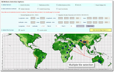

The CGIAR-CSI GeoPortal is able to provide SRTM 90m and 250m Digital Elevation Data for the entire world. The SRTM digital elevation data, produced by NASA originally, is a major breakthrough in digital mapping of the world, and provides a major advance in the accessibility of high quality elevation data for large portions of the tropics and other areas of the developing world. The SRTM digital elevation data provided on this site has been processed to fill data voids, and to facilitate it's ease of use by a wide group of potential users. This data is provided in an effort to promote the use of geospatial science and applications for sustainable development and resource conservation in the developing world. Digital elevation models (DEM) for the entire globe, covering all of the countries of the world, are available for download on this site.
The SRTM 90m DEM's have a resolution of 90m and 250m at the equator, and are provided in mosaiced 5 deg x 5 deg tiles for easy download and use. All are produced from a seamless dataset to allow easy mosaicing. These are available in both ArcInfo ASCII and GeoTiff format to facilitate their ease of use in a variety of image processing and GIS applications. Data can be downloaded using a browser or accessed directly from the ftp site
For more information and direct FREE data downloads, visit:http://srtm.csi.cgiar.org/
OR If you want to go DIRECTLY to Data Download page: CLICK HERE !